 The evacuation of the entire population of the southern Queensland town of St George, under threat from floodwaters, was averted earlier this month thanks largely to the quick action of Flinders University’s Jorg Hacker and his colleagues.
Associate Professor Hacker, Director and Chief Scientist of Airborne Research Australia, had conducted detailed aerial elevation mapping of the area last year in a research project studying powerlines and vegetation with partners Ergon Energy and airborne intelligence business, Gentol.
Responding to news reports that St George was set to experience its worst flood in more than 120 years and that all of its 3000 residents would have to leave, he offered the data to the Balonne Shire.
“In consultation with my Queensland colleagues, I sent maps of the terrain of the area, overlaid with a representation of how the town would be affected by floodwater at different levels,” Associate Professor Hacker said.
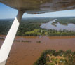
“The worst case scenario of the Balonne River peaking at 14 metres had the entire town under water,” he said.
“The maps were immediately put up on the wall of the emergency response crisis room and guided the Shire’s decision to only evacuate the hospital and aged care home. It also made them confident that the town oval, the main evacuation point, was safe.”
In response to Prime Minister Kevin Rudd’s offer of help, Shire Mayor Donna Stewart asked for real-time aerial flood mapping to guide their decision-making.
Within hours Associate Professor Hacker got a phone call from Canberra and, next morning, he flew seven hours to St George to start a hectic week of flying and data analysis.
“My ARA colleagues, Wolfgang Lieff and Helmut Thompson, dropped everything and worked all day to configure the plane with the laser scanning equipment,” he said.
“I flew for about six hours on each of three days laser-scanning the townships of St George, Hebel and Dirranbandi with Wolfgang Lieff, in a motel room at St George, converting the data into terrain elevation maps, making the task an extremely interesting research project into rapid response under emergency situations.
“Normally it takes weeks to process the amount of data we collected but, as it had to be done in a few hours, we tried to pull out the critical data to present that evening to the emergency management meeting, so they could decide what to do the next day.”
Associate Professor Hacker said the hectic episode has firmed plans to set up an emergency response operation with Gentol.
“People really learned how to appreciate the data we can produce. It was very satisfying to know that we could do something very tangible that clearly helped people in a desperate situation. It was a dramatic opportunity for us.”